
This year I am bicycling the Katy Trail for the third time...in another way. It is by far the most mileage. At the time of this blog, I am a little short of halfway. I plan to get back into it as the weather cools and hopefully gas prices go down in September and October. I am challenged by Missouri Governor Jay Nixon and his wife who are encouraging citizens to get active: 100missourimiles.com
I am passed the 100 mile challenge and have a new goal of 500 miles by the end of this year. I am at 269 miles which includes all trail activity to date. Got a nice letter from Missouri Governor jay Nixon and a medal. Maybe there will be something when I make 500??? I was email that it is in the works and more information will be available later this year.

The Katy Trail State Park is the longest developed rail-trail in the United States. There are 26 trail heads on the original 240 mile long railroad corridor. It has been designated as an official segment of the Lewis and Clark National Historic Trail. It is also a part of the American Discovery Trail and designated as a Millennium Legacy Trail. It was added to the Rails-to-Trails Conservancy Hall of Fame in 2008. The 20-year anniversary was in 2010. I started riding in 1994 and my 20th anniversary will be in 2014, the year I turn 60. Maybe I will do it again for the fourth time?
bikekatytrail.com
The first time I biked the Katy Trail was from June 10, 2000 to October 14, 2000. Keith and I did it together on weekends. The total trip took nine days and two vehicles with one overnight stay in St. Charles. We added about 50 miles and an extra day by riding from the end of the trail at Clinton to the Kansas State Line by highway. The trail end milepost at Clinton shows 264.6 miles. That's about 315 miles not counting all the extra miles sight-seeing off the trail in towns and finding the locations to get our passports stamped. We were challenged by a celebration to mark the Katy Trail as a designated Millennium Legacy Trail. It was only one of 50 trails in the United States. We got passbooks to be stamped at each participating town on or near the trail. There were 22 towns/cities participating. We also got the T-shirt and patch. It was not done in any order but the segments were anywhere from 35 miles to 50 miles per day. The days got longer as we drove both vehicles first to an end designation leaving the car, then together drove in the truck with the bikes and parked at the starting designation. We rode the bikes to the car then Keith drove the car back to get the truck as I stayed with the bikes. Then he drove the truck back to me, we loaded up the bikes on the truck and drove both vehicles home. Lots of gas and time. Lots of fun!
The second time I biked the Katy Trail was May 2, 2003 to May 8, 2003. I did it alone. It was seven days and six nights staying at four different bed and breakfasts inns (one twice) and one motel. The total miles traveled on the trail was 262.6 and the actual miles was 288. I used the services of a shuttle cab in St. Charles to get to the Amtrak Station that took me and my bike back to Sedalia's Amtrak Station. There the B&B owners where I had stayed on the first night, picked me up with their shuttle service back to the B&B. I added miles by riding again from Sedalia to my car parked at the police station in Clinton. My total cost for the trip was $540.85. That trip was well documented with photos and daily journaling. The people I met were so helpful and friendly! The biggest challenge on this trip was that it occurred at the same time dozens of tornadoes were ripping through Missouri taking over 20 lives and destroying major parts of the state including Pierce City, Stockton, and in Camden County. The tornadoes came from the south-western part of the state traveling north-east. I started out in south-central Missouri traveling north-east. I stayed ahead of it, it appeared, as May 3rd was the worst day in the south-west leveling both the downtown districts of Pierce City and Stockton (50 miles SW of my hometown of Hermitage). I only had rain about 2 hours the whole bike trip! I stopped counting all the trees downed after 20; blown down across the trail during the nights when the storms came in. I did not see anyone else on the trail May 3-4 and I was probably pretty lucky. I had a good experience overall but looking back, it was probably too risky. I was in it and rode on. My inspiration was my son, Jacob, who was an army medic in the initial invasion of Iraq and was somewhere in the field unable to call me to say he was safe. Later, he was awarded a medal of honor for his part in the heroics that took place at the Baghdad Airport. Somehow God kept us connected and somehow we both made it. Love can do that. Lots of praying going on!
I am about halfway through my third time biking the Katy Trail. I began June 18, 2013 and hope to have it done by the time the weather gets too cold in November. I have completed 86.3 miles of the trail in four days so far but actual travel is twice that as I park my car, ride my bike to the designation, turn around and ride back to my car. So that's 172.6 miles done so far. I probably won't go close to the trail's end as the best of the trail is up to and including Augusta which is 66 miles short of St. Charles and the Mississippi River. So about 200 miles is my goal which I will make into 400 miles actually by backtracking. I am seriously considering staying overnight as the days get shorter to save gas and time. Also, there's about 20 miles of wineries on the trail that I like to stay awhile and enjoy! For now, I will blog about my bike trips so far this year as I stopped a lot and enjoyed the scenery and took pictures. I hope to pick up again next month and will blog more about each trip's experience.
Since gas prices are so high lately (about $3.50/gal), I have been taking advantage of closer trails to stay active. Several days a week, I walk on the 3-mile trail below the Pomme de Terre dam which is only a few miles from my home. I also have done half of the Frisco Highline Trail (Bolivar to Springfield - 35 miles) and probably will complete it before I continue on the Katy Trail next month. It's a rougher ride.
Clinton to Windsor - 16.6 miles
This segment I have done countless times over the years since I began biking as an adult in 1994. It is the newest part of the trail which was completed about 1998. I live about 40 minutes away.

 |
| Lovely flowers and bench site near a bridge |
 |
| Mennonite area has horse and buggies as a common site
Windsor to Sedalia - 20.90 miles
This ends at the train depot that had been beautifully restored a few years ago and is vintage 1896. There are 3 other restored train depots on the Katy Trail.
 
Many of the old original rail bridges have been modified for the trail and along with all the trail maintenance, are kept up through Missouri State Park funds. It began from a $2.2 million donation of Ted and Pat Jones, son of the founder of Edward Jones financial business based in St. Louis, MO. Missouri-Kansas-Texas (MKT) Railroad abandoned the land and it became available. Other railways also joined the MKT. The common name became Katy.

Along the trail, I found some lovely and tasty dewberries which grow along the ground.
  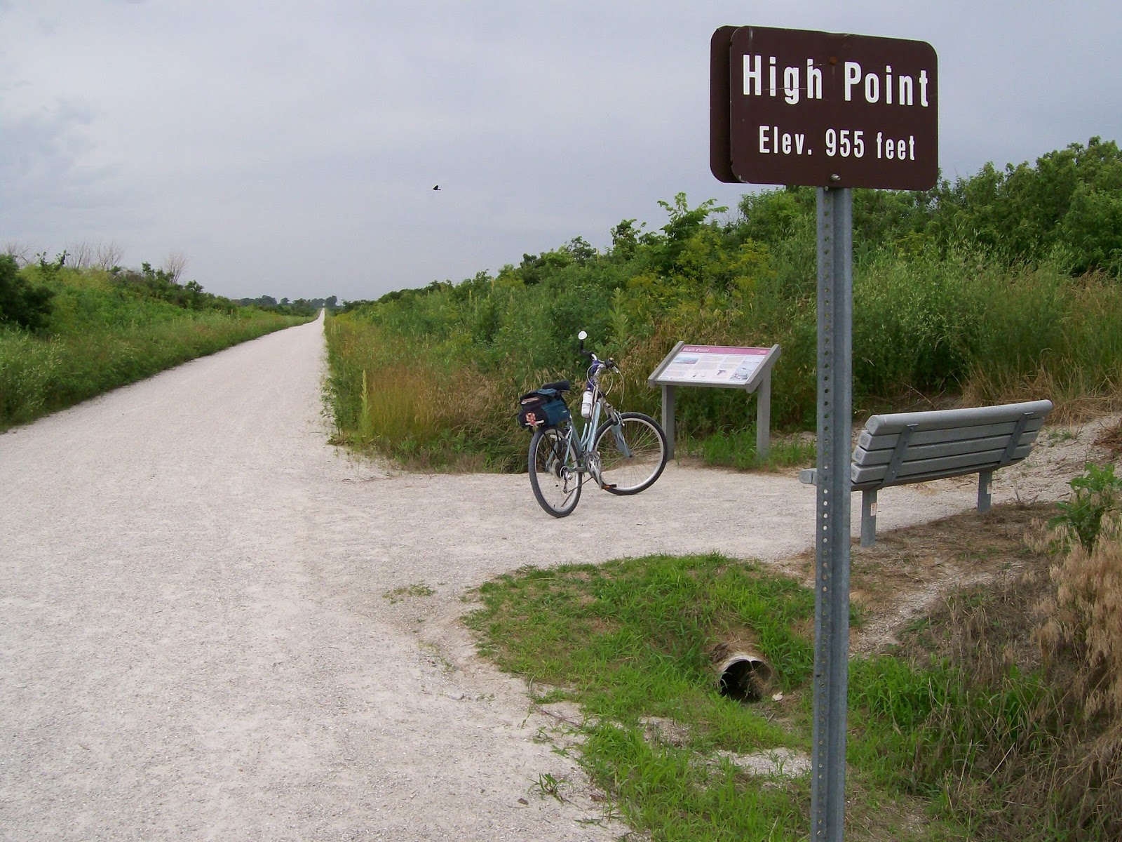
The highest point is in this segment. Overall, the grade does not change more than 2% to make for near-level riding.
 Milkweed 
My Giant bicycle keeps me rolling right along. It is a hybrid (mountain/road bike).
 
There are no horse and buggies allowed on the trail although there are a couple segments that allow horse riders.
 Saw an Indigo Bunting bird on the old telegraph pole. 
Queen Ann's Lace
 Black-eyed Susan  
Wild Roses are abundant and fragrant. One of the best things about the rail-to-trail concept is that native plants are thriving! Many of the fields along the trails' edge have long ago eradicated these natives grasses and plants in favor of crops.
Sedalia to Pilot Grove - 23.80 miles
This segment changes from the Ozark Mountains to the Osage Plains and is predominantly agricultural.
   Chicory field   The Lamine River  Old train signal  Old telegraph pole and chicory along trail  There were two of these metal tunnels along the trail. I loved to ring my bell through it!
Pilot Grove to Booneville - 11.50 miles; the end of the West Management Section
Rocheport - 13.50 miles (25 miles total)
"The Katy Trail is divided into four sections and is managed by four different Missouri state parks. Each section has its own unique flavor and characteristics with a blend of nature, history and community charm. This diversity is one of the trail's main appeals and why users keep coming back again and again to experience the entire trail."Katy Trail State Park - Missouri State Parks"
  Made it to the Missouri River! |

The new bridge across the Missouri River (photo taken from trail along casino)

The old bridge not is use but has had interest and a campaign to restore for the Katy Trail (photo taken from new bridge)

View of casino and old bridge as taken from new bridge

Good bike lane on new bridge


Old roundhouse in Franklin was used to turn engines around


Clay tile grain elevator on trail at the defunct town of Pearsons

Trailside Cafe at Rocheport is a good place to stop and shop

The only rock tunnel on the trail is near Rocheport
By July 8th, it was getting too hot with temperatures in the mid-90's. It took me four days to go this far and I will pick up again likely in September. By now the drive was almost two hours one-way, bike 5-6 hours which includes the return trip, and then drive home two hours. I will begin again with the Mid-West Section which I will drive to Jefferson City and bike west and back. Then I will drive again to Jefferson City and bike east and back as Jefferson City in about midway and closest to my home at about two hours drive. After that, I will consider overnight stays midway between two designations...and drink some wine during Octoberfest!
In the meantime, I have walked the 3-mile trail below the nearby dam and biked the Frisco Highline Trail from Bolivar to Springfield. Bolivar is only 30 miles from my home. I bicycled the trail in two segments: Bolivar to Walnut Grove in July and then Walnut Grove to Springfield in August. The Bolivar to Walnut Grove segment is a much rougher, newer trail than the Katy. The second part was mostly paved and exceptionally easy. The Frisco Highline Rail-Trail is all volunteer-funded by the Ozark Greenways organization which includes many Springfield trails. friscohighlinetrail.org

This is where I turned around and biked back to Bolivar where my car was parked.

Bridge over Sac River

Rough patch

Passion Flower Fruit

Passion Flower

Sweet Peas

Wild Bergamot
 My favorite place to go for ice cream in Walnut Grove!

Funding for the trail was greatly enhanced by government stimulus money.

This whole trail has abundant passion flowers as well as many other wildflowers.

Sumac

Sumac along on the trail

Trumpet Vines

The Springfield end of the trail - here I turned around and rode back to my car in Walnut Grove.
I will continue writing about my bicycling experiences for 2013 in October when I have completed the rest of the Katy Trail.
No comments:
Post a Comment